METHODS | APPLICATIONS |
| |||
SEISMICS | Refraction Reflection-Tomography
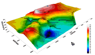
| Applied research in hydrogeological, environmental and geotechnical applications, mainly for the mapping of the rocky basement |
| 3D illustration of marls roof in the area of Paleochora for the creation of a reservoir | |
Multichannel analysis of surface waves (MASW) | Determination of the vertical and lateral change of the velocities of the transverse seismic waves |
| Layer demarcation in Monfalcone, Italy | ||
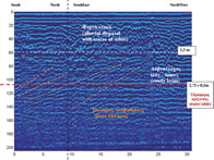
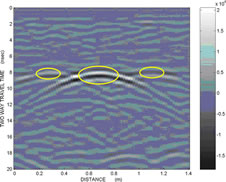
Electromagnetic | Georadar - Electromagnetic | Determining the depth of the aquifer using georadar data Detection of buried antiquities, piping |
| Determining the depth of the aquifer using georadar data
| |
| Buried piping, as shown in georadar data.
| ||||
Electrical
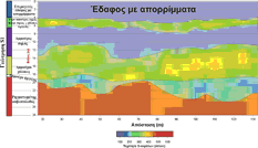
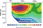
| Vertical electrical sounding Tomography | Hydrogeological, Environmental and Geotechnical applications |
| The seawater inflow zone is represented by low specific electrical resistances. Industrial area of Heraklion | |
Magnetic | Magnetic mapping | Detection of buried antiquities
|
| Itanos | |